Crimean Resorts
Historical document, translated for reference. It reflects medical knowledge of the 1920s–30s and is not medical advice.
Summary
The Crimea is described as an extensive group of health resorts located on the Crimean Peninsula, with diverse geography, geology, and climate that create unique therapeutic conditions. The article details the peninsula's physical features, geological formation, and climatic characteristics that make it suitable for medical tourism.
Encyclopedia article (1928–1936)
CRIMEAN RESORTS, an extensive group of resorts of the USSR, located on the Crimean Peninsula. Crimea is the southernmost extremity of the European part of the USSR. It is washed by the sea on almost all sides: by the Black Sea on the west and south, and by the Sea of Azov on the east. It is connected with the mainland by the narrow, 8 km wide, Perekop Isthmus. The northern coast of Crimea is deeply indented and washed by the large saltwater lake Sivash. To the east, Crimea extends into the long Kerch Peninsula, separated from the Caucasian shore by the narrow Kerch Strait. Crimea lies between 46°21' and 44°23' north latitude and 32°30' and 36°41' east longitude from Greenwich. From north to south, Crimea stretches approximately 200 km, and from west to east about 320 km. The total area of the peninsula is about 25,300 km². The nature of Crimea is very diverse and picturesque; the historical destinies of Crimea were also distinguished by great diversity, having since ancient times stood at the junction of different cultures. Relief of Crimea. In terms of relief, the northern steppe part of the Crimean Peninsula is a smooth plain, little different from the steppes of southern Ukraine. The northern coasts of Crimea are low-lying salt marshes, recently covered by the sea. Numerous salt lakes further support this assumption. To the south, the relief becomes more lively; from Simferopol begins the area of foothills, stretching from Sevastopol to Feodosia, generally in two ridges: a lower tertiary ridge of yellowish limestones and variegated marls, 150-300 m high, and a higher chalk ridge, formed by chalk-like marls and breaking off to the south with steep cliffs. The height of some peaks of the chalk ridge is up to 600 m. The railway from Simferopol to Sevastopol runs in a depression between these two ridges. From the steep cliffs of the second (chalk) ridge opens a majestic view of the main, or Yaila, mountain ridge, which extends from Balaklava to Feodosia. This ridge at its base is composed of dark clayey slates, on which lie dense sandstones, conglomerates, and gray marble-like limestones. The top of the main ridge over most of its length is formed by a rocky plateau - the Yaila. The main ridge is significantly higher than the two ridges of the foothill area (its highest point - Roman-Kosh - 1,543 m). To the south, the main ridge breaks off with steep cliffs. The narrow (2-8 km wide) strip of the southern slope, washed by the Black Sea, is called the Southern Coast. The small size of the peninsula and the comparative dryness of the climate do not allow for the development of any large rivers here. All Crimean streams are insignificant mountain streams, turbulent in spring when the snow melts in the mountains, and almost drying up in summer. Geology of Crimea. The geological structure of the Crimean Peninsula is outlined in the accompanying schematic geological map. The modern forms of relief of Crimea are the result of various changes in its surface over a long series of centuries. The youngest geological area of the Crimean Peninsula is its northern steppe part: under the layer of chernozem soil or loams here lie shell limestones and marls, deposited on the bottom of the tertiary sea, which covered southern Ukraine and the steppe Crimea. The second (chalk ridge) is composed of sandstones and chalk-like marls of much more ancient age (Cretaceous period). The most ancient part of Crimea is its main ridge, formed by limestones, sandstones, and slates of Jurassic, partly Triassic period. In particular - the gray marble-like limestones forming the steep cliff of the Yaila are nothing more than the remains of a coral reef that once rose from the bottom of the Upper Jurassic sea. The underlying schistose (clayey) slates were once deposited as silt on the bottom of the older seas of the Triassic and Lower Jurassic periods. The clayey slates in the process of the rise of the Crimean Mountains have been folded into bizarre folds, and the Yaila limestones have been split by numerous fault fractures. The funnels and caves of the Yaila plateau bear traces of the combined action of water and air (so-called 'karst' weathering). The cliff of the Yaila itself to the sea was formed due to a grandiose fault. The mountainous part of Crimea is a surviving fragment of the ancient extensive Pontic land, which apparently sank at the end of the tertiary period and formed the deep depression of the Black Sea. In addition to sedimentary rocks, in the mountainous part of Crimea there are numerous outcrops of volcanic, massive-crystalline rocks, thrust up from the molten depths of the earth during the formation of the Crimean Mountains (throughout the entire Jurassic period). Most of them belong to the type of intrusions, i.e., the molten masses did not reach the surface of the earth, but solidified in the crust, only raising its upper layers. Many mountains in Crimea belong to these so-called laccoliths. In addition, there are effusive rocks in Crimea, i.e., formed during actual volcanic eruptions; five strongly destroyed ancient volcanoes are known, which ceased to operate hundreds of millions of years ago (Karadag). On the Kerch Peninsula there are so-called mud volcanoes, erupting liquid cold mud. Mountain-forming processes and volcanic eruptions in Crimea have long ended. But this does not mean that the relief of Crimea represents something finished, unchanging; flowing waters constantly erode the slopes of its mountains; steep cliffs of the southern slope, destroyed by the action of water and atmosphere, sometimes collapse in terrifying landslides; underground waters, softening the clayey slates of the southern coast, cause destructive landslides. The processes of subsidence of the earth's crust, continuing in the depths of the Black Sea, from time to time make themselves known by light or rather significant earthquakes. The last earthquake was in September 1927. - The sea washing the Crimean Peninsula has many peculiarities. The Black Sea to the south of Crimea has considerable depths, the coast drops steeply. On the contrary, the northwestern corner of the Black Sea, the so-called Karkinitsky Bay, is relatively shallow, and the Sea of Azov is even shallower. This distribution of depths affects the water temperature: in winter, the shallow parts of the Black and Azov seas cool to the bottom and are often covered with ice on the surface. On the contrary, the deep sea to the south of Crimea not only never freezes, but its surface layers do not cool below +6°, while at depth a constant temperature of about +9° is always observed. These physical-geographical features of Crimea and the sea washing it, as well as the geological past of the peninsula, determine the character of its climate, vegetation, and medicinal properties. Climate of Crimea. The influence of the sea is clearly reflected in the climate of Crimea, but this influence manifests itself far from uniformly over the entire territory. The mountains of Crimea rise like a solid wall in its south-southeastern part and descend in a series of successive dissected cliffs to the north-northwest. The influence of the mountains on the climate is twofold. Located in the path of winds, the mountains hinder their horizontal spread and force air masses to rise upward or to cross over the ridge. In this case, they contribute to the enhanced precipitation of atmospheric precipitation on the windward slope of the mountains and the drying of the air on the leeward slope. Another influence of the mountains is the protection of the leeward side of the mountains from air currents: cold ones - usually from the north and warm ones - from the south. Thanks to this influence, the coastal strip of Crimea at the foot of the high Yaila on the southern slope, the so-called southern coast, differs by its high temperature and a number of other features of its climate from the nearest parts of Crimea. Cold northwestern winds, very often blowing from the northern part of Crimea onto the plains, do not penetrate to the southern coast, which enjoys the full southern sun and moisture of the neighboring warm sea. Crimea is under the strong influence of the Central Asian high-pressure area for 4-6 cold months, from where in the cold season dry air currents are carried to the warmer Mediterranean Sea. At this time of year, the sea is much warmer than the land, the air above it is warmer and more humid, and therefore less dense than above the land, and consequently the general direction of air currents at this time of year should be from northeast to southwest. This is usually the case in colder winters in Crimea. But sometimes in warm winters in Crimea, western and southwestern winds prevail. This happens in cases when the Central Asian high-pressure area is underdeveloped and high pressure developing in western Europe, starting from the Azores islands, and spreading over the Mediterranean Sea takes precedence over it. Thus, Crimea is in the area of variable winter winds: depending on their direction, the winter regime is established in Crimea. As for the summer time, in this case the matter turns out to be somewhat simpler. The sea in summer is always colder than the land, therefore the air flow in summer will always be from the sea, and southwestern winds are characteristic of Crimean summer. The average annual air temperature in Crimea varies in different places from 4° to 13°. It is higher in the west, decreases to the east, and is highest on the southern coast. This strip of greatest heating occupies no more than 2-3 km in depth from the shore and extends from Cape Sarych almost to the coast of Alushta.
As one moves away from the sea and the elevation increases, the temperature decreases; the highest points of Yaila have an average annual temperature from 4° to 10°, but this zone is very limited: from 10 to 30 km in width and about 100-120 km in length. Thus, thanks to the presence of mountains in Crimea, within a distance of only 10-25 km, there are temperature changes that are observed in the rest of the European part of the USSR not closer than at a distance of 1,500 km. Such sharp temperature changes are observed in Crimea on a very small territory, when transitioning from the peaks of Yaila to the southern coast. On the northern side of Yaila, as the terrain gradually lowers, the isotherms decrease more slowly. More detailed data on average annual and average monthly temperatures can be seen in Table 1. Climatologists divide the year in Crimea into two half-years: cold and warm. Dmitriev characterizes the cold half-year on the southern coast as a long five-month period, mostly good northern autumn, like a good September stretched out for almost half a year. Clear, dry, warm days are replaced by brief night or even daytime frosts or rainy days, never lasting for long. During winter, not only in November and December, but even in January and February, it is not uncommon to have such warm, clear, calm days as occur in the north only in May or August. Table 2, compiled by Sergeevsky for 1901-20, gives the climatological characteristics of typical Yalta winters. The climateological characteristic of typical Yalta winters is given by Table 2, compiled by Sergeevsky for 1901-20. The mountains are higher than the sea, and air masses coming from the sea, when contacting the heated land, are heated, as a result of which their relative humidity decreases. In the central and northern parts of Crimea, 300 to 500 mm of precipitation falls per year; precipitation is greater on the southern coast (up to 700 mm) and on mountain peaks (up to 1,000 mm). A more detailed characterization of atmospheric precipitation and their annual course in various places of Crimea is given in Table 3 and on the map. The temperature of sea water off the coast of Crimea, important as a climatic and balneological factor, is characterized by Table 4. Table 2. Months December Duration of sunshine in hours (S) Pressure Temperature of air Variability of t° from one day to another Relative humidity in percent Absolute humidity Amount of precipitation (sum) Cloudiness (in tenths) Jan. Feb. Mar. Apr. May June July Aug. Sept. Oct. Nov. 174,9 96,4 68,7 75,0 90,7 134,0 188,4 763,8 764,1 763,8 763,5 762,8 761,4 760,9 14,2 9,1 6,3 3,8 4,0 6,2 10,6 1,47 1,94 1,84 1,80 1,86 1,64 1,51 71 72 74 73 73 71 66 8,6 6,5 5,6 4,6 4,6 5,2 6,3 48,5 4,4 5,6 6,0 6,1 6,6 5,6 61,3 64,5 67,1 47,5 48,0 31,0 5,0 Summer in Crimea is hot, with an average temperature from 20° to 24°, the most stable time of year. On the coast, high humidity at high temperature has little effect on the sick organism, but this is noted only down by the sea. As soon as one ascends a bit higher into the mountains, the temperature and humidity quickly decrease. Autumn in Crimea is the best time of year. As a feature of the coastal climate in Crimea, one should note the very small fluctuations in temperature within a day. Extreme monthly temperature values may deviate from those indicated in Table 1 by approximately 12-15°. Crimea lies in a zone poor in precipitation, despite being surrounded by sea on almost all sides. The reason for this should be sought in the prevailing air currents. In winter, cold and dry winds from the land prevail in Crimea. In summer, winds from the sea prevail, but the moisture they bring does not produce precipitation, since at this time the land is heated. Table 5 characterizes sunshine in Crimea and expresses (in percent) the ratio of the duration of actual sunshine to the possible duration based on geographical location. Such is the general characterization of the climate of Crimea. The work carried out in the last five years by the Yalta tubercular institute in studying the microclimate has shown that against this general background there is scattered a diverse range of climatic conditions, which is of great interest for climatotherapy on the southern coast and in the mountainous regions of Crimea. Vegetation of Crimea. The above-mentioned features in the distribution of temperature and precipitation to a large extent determine the character of Crimean vegetation. The steppe region is treeless, because at the latitude of Crimea with 300 mm of annual precipitation, a forest cannot grow. Depending on the soil, the Crimean steppes show a very different character: on the solonchaks adjacent to the sea, the vegetation is sparse, with predominance of saltworts and wormwood, in more suitable places-feather grass. The central part of the steppe region with fertile chernozem soils is covered, in places free from plowing, with a mixed-grass steppe with a rich flora of grasses and dicotyledonous plants. When moving southward, to the foothills, already in the Tertiary ridge area, remnants of low forests (oak groves) begin to appear, which once completely covered the slopes and peaks of the Tertiary, and especially the Chalk ridge. Further south, on the northern spurs of the main ridge, the humidity conditions already allow for the development of real forests, predominantly oak, with a dense undergrowth of hornbeam, cornelian cherry, hazel, sumac, and dogwood. Above 500 m above sea level, the humidity of the atmosphere becomes sufficient for the growth of now heavily cut beech forests with an admixture of hornbeam, maple, ash, and yew, and in places also common pine. The top of the main Yaila ridge represents a treeless stony plateau. There are reasons to assume that the treelessness of Yaila is the result of human felling of the beech-hornbeam forests that once covered it. On the southern slope of the main ridge in the upper horizons, beech predominates, lower down-predominantly Crimean pine. The southernmost coast, i.e., the strip of the southern slope of the mountains below 300-400 m above sea level, Table 5. Duration of sunshine in percent. Months Jan. Feb. Mar. Apr. May June July Aug. Sept. Oct. Nov. Dec. Average value... 49 49 57 57 58 67 74 74 60 49 32 32 Table 3. Average multiannual precipitation in mm. Foros....... Livadia ...... Yalta........ Alushta...... Sudak....... Sevastopol . . . Feodosia ..... Kerch ....... Ay-Petri..... Magdus....... Nikitskaya dacha . . Karabi-Yayla . . . Stary Krym . . Simferopol . . Karasubazar . . . Evpatoria . . . Saki........ Demerji..... Gurzuf ....... Balaklava. . . . Verkhovya Uchan-Su Pendiкуль . . . Baidary ...... Simeiz ....... Ay-Todor..... 33 96 65 43 46 143 153 52 86 45 75 49 36 21 25 20 20 95 47 56 31 34 27 24 28 17 14 39 30 50 80 58 37 43 53 44 34 21 25 25 23 83 50 50 25 44 32 26 25 20 27 48 28 52 79 42 58 42 33 35 31 25 22 25 26 27 45 39 38 24 41 32 32 27 22 28 23 20 39 42 33 34 25 20 29 28 19 20 20 25 26 51 42 40 53 52 34 37 29 21 51 41 26 68 74 28 33 18 31 52 43 38 32 26 45 54 79 65 67 61 75 57 67 36 36 33 28 32 87 50 52 40 29 14 41 44 31 40 28 36 45 70 76 78 68 43 58 59 34 35 45 46 30 100 72 43 43 20 38 35 27 21 38 29 33 61 53 46 20 27 35 28 23 23 47 25 41 95 82 38 34 24 33 59 45 45 26 35 28 26 82 62 54 42 28 26 27 36 40 44 57 39 84 82 52 54 38 23 75 62 49 22 40 32 30 97 76 73 35 37 32 31 25 18 50 55 42 89 100 58 52 53 50 86 72 40 31 43 25 28 110 63 65 59 48 41 27 30 22 70 84 42 94 154 70 78 44 381 666 545 418 295 361 341 375 819 667 673 486 500 437 408 349 305 470 529 394 958 1.006 549 579 398 Table 4. Temperature of sea water on the surface. Months January February March April May June July August September October November December Average annual
Evpatoria-Tarkhankut ria 4,1 4,7 5,9 8,6 13,8 18,4 19,8 20,4 18,6 15,0 10,5 6,9 12,2 5,6 3,2 6,2 10,9 14,6 19,1 20,0 21,8 19,6 15,5 9,7 6,1 12,7 Sevastopol 6,2 6,1 7,4 9,5 15,1 20,2 23,6 23,3 20,7 16,4 12,0 8,5 14,1 and Sudak Feodosiya Chauda Kerch 8,7 5,6 2,6 3,4 6,4 4,1 3,3 2,4 7,8 5,9 5,6 4,4 11,6 9,4 9,1 10,5 14,8 14,0 15,4 16,4 18,7 17,5 19,9 21,0 22,7 19,8 22,7 24,0 22,2 21,1 22,0 23,3 20,2 19,3 18,3 19,8 17,4 15,5 14,1 14,4 13,7 10,8 8,8 1 8,4 11,2 7,3 5,5 4,7 14,6 12,5 li,3 12,7 has preserved its natural vegetation in only a few places, which in more humid areas consists of groves of oak, turpentine tree, arbutus, densely intertwined with ivy and clematis vines, with an impenetrable undergrowth of sumac, dogwood, buckthorn, and prickly juniper. On more rocky areas, fragrant light groves of tree-like juniper have been preserved. In most cases, these natural groves have been cut down and replaced by either poor shrub growth or The following areas are most well-known in this respect: a) on the western coast of Crimea - Evpatoria (see), Sevastopol, Balaklava (see); b) on the southern coast - Simeiz, Alupka (see), Miskhor, Yalta (see) with its surroundings - Livadia (see), Oreanda, Massandra, Gurzuf (see), Suuk-su, Alushta (see); c) on the eastern coast - Koktebel, Sudak and Feodosia (see). The southern coast of Crimea (from Baidar to Sudak) is particularly popular. In winter, the climate, treatment is conducted mainly on the resorts of the southern co
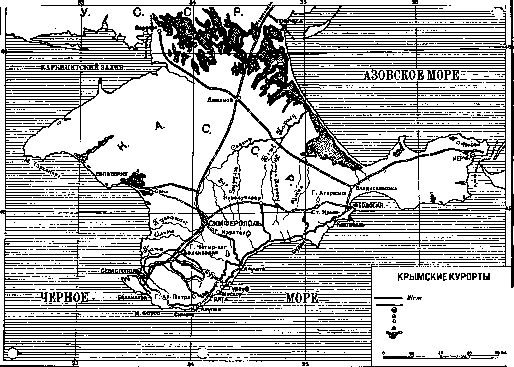
- - r- Boundaries of the Crimean ASSR. Roads. Highway Central/ASSR. Large populated points. Other populated points. Mineral springs. Salt-sulfur mud lakes. The southern coast of Crimea is covered with cultural plantings: vineyards, tobacco plantations, gardens and parks. The vegetation of the parks is almost entirely of foreign origin. The favorable climate of the southern coast makes it possible to grow a number of southern species, brought mainly from Mediterranean countries, partly from Japan and America. These include cypress, laurel, cedar, Persian acacia, plane trees, chestnut, magnolia, oleander, fan palm, bamboo, olive, fig tree, etc. Climatic features of Crimean resorts. The combination of diverse healing forces has given Crimea the rightful right to be called the All-Union health resort. Favorable climatic features have created the main fame of Crimea as a place for climatic treatment of various ailments in adults and children, especially for the treatment of tuberculosis. These features are used in summer by a large number of patients and vacationers. Many areas of Crimea are known as seaside climatic stations, where air and sun baths and sea bathing are widely used (see map). The southern coast of Crimea, where most Crimean resorts, sanatoriums and rest homes are located. In the autumn months (August-October), grape therapy is conducted at the climatic Crimean resorts (see). In the last 50 years, Crimean doctors have repeatedly raised the question of organizing climatic stations in the mountains of Crimea, especially on the southern slope of Yaila. There it is possible to conduct climatic treatment both in the zone of small altitudes up to 500 m above sea level, and in the subalpine zone at an altitude from 500 to 800 m. In various places on the southern slope of Yaila, there are more than 15 areas suitable for mountain climatic stations. The establishment and development of such stations in Crimea is especially desirable in view of the hot summer in coastal areas. This is a task for the future. At present, in Crimea, only three mountain climatic stations are functioning (near Yalta): Dolossy (400 m), Ereklik (460 m) and Tuzler (680 m). The question of indications for treatment on the southern coast of Crimea is summarized by the workers of the Resort Administration of the People's Commissariat of Health. Patients with tuberculosis of the lungs in the stage of subcompensation without large temperature fluctuations, without frequent and abundant hemorrhages, with processes of a predominantly productive nature, stationary or slowly progressive, should be sent to the resorts of the southern coast of Crimea. However, such patients should be sent only for the period from mid-September to mid-May. In summer, there are strong heats here, and pulmonary tuberculosis patients begin to feel unwell, lose weight, and often develop hemoptysis. In summer, only patients with a small tuberculous process in the stage of complete compensation, when there is no danger of hemoptysis and sun treatment can be conducted, can be treated here. In addition to these diseases, the following are indicated throughout the year: tuberculosis of the larynx without deep damage to the cartilage, without signs of stenosis and severe dysphagia, tuberculosis of the bronchial glands with subfebrile temperature, tuberculosis of joints and bones, tuberculosis of the skin, genitourinary system (kidneys, bladder, testicles, uterus and its appendages) without hectic fever and cachexia, exudative serous pleurisy, non-tuberculous lung diseases, catarrhs of the upper respiratory tract, unresolved pneumonias, bronchitis, anemia, chlorosis, chronic malaria, chronic intoxication in the period of recovery after severe diseases and operations, parenchymatous nephritis, rickets and exudative diathesis in children. Contraindications regardless of the time of year are: tuberculosis of the lungs in the stage of decompensation, rapidly progressive, with signs of severe exhaustion, with frequent hemoptysis, constant hectic temperature; widespread tuberculosis of the larynx with simultaneous damage to adjacent areas (pharynx, palate, fauces, tongue); severe lesions of bones, joints, glands and peritoneum with abundant pus discharge, high temperature and severe exhaustion; pronounced tuberculosis of the intestine; tuberculosis complicated by irritative forms of neuroses. Winter season at Crimean resorts. The tables above give a detailed description of the climatic conditions of the cold half-year in Crimea. The data on air temperature, precipitation and duration of sunshine, especially thoroughly developed for the winter climate of Yalta (see table 2), show that in winter Crimea (especially the southern coast) is a place with a mild, gentle climate. The Yaila ridge protects the southern coast from cold winds from the mainland. These climatic conditions make the autumn-winter season at Crimean resorts the best time for treating many patients on the southern coast. The list of indications (see above) shows that in the winter season at Crimean resorts, various tuberculous and non-tuberculous diseases can be successfully treated. Winter treatment at Crimean resorts is gradually developing. At present, winter treatment is conducted in Yalta, Sevastopol, Alupka, Evpatoria. Balneological Crimean resorts. Among the healing natural forces of Crimea, salt lakes and sea muds play a prominent role. A large number of salt mud lakes are scattered throughout the Crimean Peninsula, forming a special Crimean group among the mud deposits of the south of the USSR (see Mud treatment areas). At present, the following salt lakes and mud lagoons are used for therapeutic purposes: Mainak near Evpatoria (see), Saki at the resort of the same name (see Saki) and Chokrak near Kerch. In Crimea, there are more than 20 mineral springs of alkaline-earth, bitter, hydrogen sulfide. Three sources have more or less firmly established a reputation as medicinal waters: Pasha-Tepe near Feodosia, Burunkay near Bakhchisarai and Katyrga-Saraysky between Karasubazar and Stary Krym. These sources are not properly exploited. Excursion services are well developed in Crimea. History of resort development in Crimea. As a place for resort treatment, Crimea has been known for about 60 years. One of the first, S.P. Botkin, drew attention to the climatic-therapeutic value of Yalta. A bright propagandist and organizer of resort development in Crimea was the doctor V.N. Dmitriev. The beginning of resort life in Yalta and Balaklava dates back to the 1870s. Resort development in Crimea gradually but slowly developed in the last quarter of the 19th century and the beginning of the 20th century. Disparate funds from various sources were invested in the organization of climatic (on the southern coast of Crimea) and balneological (in Mainaki, Saki and Chokrak) treatment: by the government (mainly the military department), the Taurida zemstvo, other zemstvos, city charitable societies (Society of Russian Doctors, Philanthropic Society, etc.), self-governments and private individuals. Governmental and public (city and zemstvo) resort establishments in the pre-revolutionary period existed in a few points: Evpatoria, Mainaki, Saki, Sevastopol, Balaklava, Alupka, Yalta, Sudak, Feodosia, Kerch. Everywhere the housing stock of the resorts was in private hands. In 1914, an institute of physical therapy methods was opened in Sevastopol. During the years of the world war, resort assistance to the wounded was developed in Crimea by the all-Russian zemstvo and city unions. Immediately after the liberation of Crimea from Wrangel's troops, the Soviet government began a new period in the history of Crimean resorts. In a special decree of December 21, 1920, on the use of Crimea for the treatment of workers, the Council of People's Commissars wrote: 'Thanks to the liberation of Crimea by the Red Army from the rule of Wrangel and the White Guards, it became possible to use the healing properties of the Crimean coast for the treatment and restoration of the working capacity of workers, peasants and all working people of all Soviet republics, as well as for workers from other countries, sent by the International Council of Trade Unions to sanatoriums and resorts of Crimea, which were previously a privilege of the large bourgeoisie. The beautiful dachas and mansions that were previously used by large landowners and capitalists, the palaces of former tsars and great princes, must be used as sanatoriums and health resorts for workers and peasants.' Most Crimean resorts were declared to have all-Union significance. Special resort administrations took on the tasks of organizing and managing Crimean resorts. Numerous sanatoriums and rest homes were developed in Crimea. In addition to the current organizational and treatment work at Crimean resorts, great scientific work is being carried out to identify the scientific basis for climatotherapy and balneotherapy in Crimea. The leading role in this regard and partly in the field of thalassotherapy is played by the Yalta Tuberculosis Institute (opened August 1, 1922) and the Sevastopol Physiotherapy Institute named after Sechenov.
Related articles
Mentioned in
Cite this page
“Crimean Resorts.” Soviet Medical Encyclopedia. English translation of Bolshaya Meditsinskaya Entsiklopediya, 1st ed. (Moscow, 1928–1936), ed. N. A. Semashko. https://sovietmedicalencyclopedia.pages.dev/article/crimean-resorts/