Land Reclamation
Historical document, translated for reference. It reflects medical knowledge of the 1920s–30s and is not medical advice.
Summary
This article from the 1928–1936 Soviet Great Medical Encyclopedia discusses land reclamation (melioration) techniques such as drainage and irrigation, highlighting their crucial role in public health, vector control, and the eradication of malaria and other diseases.
Encyclopedia article (1928–1936)
MELIORATION (from Latin melioratio — improvement), refers to fundamental land improvements that affect the natural-historical conditions of agriculture and forestry through agronomic (agrotechnical meliorations, or agricultural melioration), silvicultural (silvicultural meliorations, or forest melioration), and hydraulic engineering methods (water, or hydraulic melioration), and can simultaneously contribute to the sanitary improvement of various localities. Waterlogged soils are usually a condition promoting the development of a number of diseases, primarily malaria; dry sandy soils in strong winds contribute to air pollution, sharply increasing the amount of dust in it. Thus, in the practice of sanitary measures, one very often has to deal with melioration both in routine minor work and in major sanitary-improvement plans. Health authorities often have to take the initiative in developing such meliorative and sanitary improvement measures, especially in malarial localities. On the other hand, when carrying out economic meliorations, certain sanitary conditions of these works are often overlooked, and as a result of this lack of coordination, major sanitary defects arise upon the completion of meliorative works (new waterlogging during irrigation works and the development of malaria). Therefore, health authorities must constantly keep abreast of all other meliorative works as well. The objects of melioration are lands unsuitable for economic activity: "inconvenient" lands, such as marshes and deserts, sands, or difficult- or little-used "waste" lands, such as "acid" and heavy clay soils, and finally "convenient" lands that are subjected to some harmful influences, such as floods, landslides, or lands covered with bushes, hummocks, etc. The distribution of inconvenient lands, the main object of melioration, is in close connection with climatic conditions, mainly with the distribution of moisture and heat. According to rough estimates in the European part of the Soviet Union, there are 15 million hectares of forest and moss bogs, 16 million hectares of grassy bogs, 2 million hectares of arid lands requiring irrigation, 6 million hectares of sands, and 1 million hectares of ravines, totaling about 40 million hectares. To these must be added 39 million hectares of northern tundras, the exploitation of which is hardly possible in the near future. Outside the European part of the Union, the area of inconvenient lands is undoubtedly very large. The main types of melioration are drainage and irrigation. Drainage works aim to remove excess surface and ground water. The causes leading to the waterlogging of lands and the formation of bogs are insufficient local slope, which impedes water runoff conditions, and the presence of impermeable soil, which retards water percolation. In the north, moreover, low temperatures exclude the possibility of evaporation of even a relatively insignificant amount of stagnant water. The result of waterlogging is the deterioration of the thermal regime of the soil due to the significant heat capacity of water and evaporation processes, late thawing of the earth, frosts, fogs, and deterioration of the aeration regime of the soil due to the filling of its pores with water and (as a consequence) changes in physicochemical soil processes, "soil souring," delay in the decomposition of organic remains, accumulation of humus, and peat formation. All this leads to the deterioration of vegetation—quantitative (decrease in grass yield and timber growth) and qualitative (appearance of sedges, mosses, stunted trees), to difficulties in land cultivation (soil stickiness, late warming), to a reduction in cultural area, and to a number of sanitary defects. The change in the character of the soil, vegetation, and microclimatic conditions thus affects agriculture and forestry, the condition of roads, and the sanitary conditions of the locality. The presence of bogs, in which water is strongly heated due to its immobility, creates favorable conditions for the development of blood-sucking insect larvae. Larvae of horseflies breed in enormous numbers in bogs; they cause great harm to humans and domestic animals by sucking blood and disturbing livestock in pastures, and also serve as mechanical transmitters of anthrax and camel trypanosomiasis. In the swampy forests of Siberia, special blood-sucking dipterans of the family Ceratopogonidae (local name "gnus" [midges]) have enormous distribution; at certain times of the year, they make it completely impossible for humans, domestic animals, and even wild animals to stay in the forest. On wet marshy meadows, ticks of the genus Ixodes are usually widespread; in the middle zone of the European part of the Union, they transmit cattle piroplasmosis. But the most important from a sanitary point of view is the breeding in bogs of mosquitoes and, in particular, Anopheles mosquitoes, which transmit human malaria. Work in waterlogged localities in peat extraction, timber rafting, and fisheries near lakes and backwaters entails a wide spread of malaria, which for these groups of workers is an occupational disease. In addition to sites for the development of blood-sucking insect larvae, bogs create the most favorable conditions for the reproduction of mollusks, which serve as intermediate hosts for several species of parasitic worms from the trematode family. The liver fluke completes its development cycle in water, predominantly in standing water, and encysts on marsh vegetation, which is eaten by livestock, leading to severe epizootics. Cercariae of the blood fluke, emerging from mollusks, attack humans when working in swamps or rice fields (in China) and actively penetrate through the skin into the bloodstream, causing a severe disease—bilharziasis (see Schistosomiasis). Drainage of bogs makes the development of the aquatic generation of insects, and in particular mosquitoes, impossible and contributes to the improvement of the locality regarding malaria. The destruction of marshy places serving for the development of ticks and mollusks improves pastures and leads to the cessation of corresponding epizootics. Drainage of damp, heavy, clayey, or peaty soils, which are subject not so much to surface water stagnation as to high humidity and low permeability, is achieved by laying underground drainage of various types (see Drainage). Drainage of an area with open ditches achieves not only a lowering of the groundwater level, but also a rapid removal of surface water even with an insignificant surface slope. In addition, this method is cheaper. However, the significant loss of land area, the difficulty of communication and cultivation, especially tractor cultivation, with frequent ditches make it necessary in cases of intensive cultivation (field, vegetable) to resort to underground drainage. Conversely, meadow lands are predominantly, and forest lands are always, drained by open ditches. The smallest lowering of the groundwater level is obtained along the middle line between the ditches. To combat malaria, a very insignificant lowering of the groundwater level is sometimes sufficient to destroy the "water mirror," i.e., its surface presence.
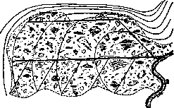
Figure 1. Drainage network of ditches: 1–5 — lateral ditches; L — main ditch; B — mountain ditch; C — stream.
In the case of hummocks, between which there are small puddles of water quite suitable for the development of malaria mosquito larvae, it is sufficient to plow the area with a tractor. To drain an area, a network of ditches is constructed, consisting of drainage or lateral ditches flowing into outlet or main ditches. Surface and groundwater coming from the slopes to waterlogged lands are intercepted by mountain ditches (Fig. 1). Obviously, main ditches must be run through the lowest places along the terrain slope, drainage ditches across the slope, and mountain ditches along the foot of the slope. Longitudinal slopes of ditches must be such that the water velocity, on the one hand, is sufficient to drain water without the ditches becoming overgrown with vegetation and silted up with sand (>0.2 m per second) and, on the other hand, does not allow erosion of the ditch bottom (<1 m per second). To eliminate conditions favoring the development of malaria mosquito larvae, the flow velocity in ditches must be greater than 0.2 meters per second. Ditches are usually given a trapezoidal shape (Fig. 2); their slopes are steeper the more stable the soil. Gentle slopes very quickly become overgrown with marsh vegetation, the flow near them slows down even more as a result, and thereby favorable conditions are created for the life of malaria mosquito larvae. In some cases, other special drainage methods are used. Thus, if an area is flooded from the side of a river or sea, it is fenced off from the water side by ramparts or dikes, which is why this method is named

Figure 2. a — large ditch with a central concrete groove; b — large ditch with drainage.
embankment (Dutch polders). Water collected in such cases by a network of drainage ditches is diverted downstream of the river or pumped out by mechanical pumps into the river or sea. Sometimes drainage is achieved by discharging water through vertical drainage, consisting of absorption wells, into underground permeable horizons. Lands drained in one way or another are used depending on the properties of the soil. Mineral soils rich in ash substances are suitable for agricultural crops (field and meadow); poorer soils are used for afforestation, and moss bogs rich in organic matter and poor in ash are exploited for fuel. During drainage, along with the general improvement of the locality due to the elimination of the harmful aspects of waterlogging, sometimes at first a temporary deterioration in sanitary conditions is also observed due to the development of processes of decomposition of organic remains that have come to the surface from under water. In cases where one of the component parts of the reclamation system is a river and its condition proves unsatisfactory for the proper operation of this system, resort is made to the improvement or regulation of rivers, i.e., the adaptation of their regime for certain purposes. Often, river improvement is necessary in cases of undercutting or for the purpose of flood control. River reclamation works boil down to giving their bed the proper cross-section, slope, and velocity for a more or less uniform passage of water that protects agricultural lands from damage during the most critical moments (snowmelt, heavy rains). Sometimes the causes of insufficient river discharge capacity are artificial structures on them: dams, fish weirs, inadequate openings of road bridges and culverts, and the like, and the mere correction of the design of these structures or their destruction is sufficient to establish the necessary river regime. To protect low-lying places from flooding by floodwaters in cases where it is impossible to lower the water level by the methods described above, recourse is made to embanking, i.e., the construction of longitudinal banks or dikes along the river. Natural regulators of river flow that smooth out water levels, velocity, and the amount of water flowing per unit of time are large, deep, flow-through lakes from which rivers flow. An example of such a river is the Neva. However, only a large reservoir, in which the arrival and depletion of significant amounts of water creates only a slight fluctuation in the water level, can serve as such a regulator for rivers. Conversely, small and shallow lakes, where the deposition of alluvium brought by their tributaries leads to an increase in the water level in them, cause the flooding of neighboring lands and backwater in tributaries. Such lakes are often bypassed by canals to divert excess water into the nearest convenient reservoir. River regulation works on a larger scale than for reclamation purposes are carried out for the needs of navigation and the use of water power. River regulation for navigation and timber rafting, in contrast to drainage work, aims to increase the water depth in rivers, which is achieved not only by dredging work, but also by

Figure 3. Straightening of river meanders.
volume of water-retaining dams on them (canalization of rivers). The construction of dams is also necessary for the installation of hydraulic engines. The construction of dams on rivers with low banks leads to the flooding of neighboring lands, an increase in the groundwater level in the surrounding area, and its waterlogging with all the harmful sanitary consequences of the latter for the population and agriculture. Conversely, works on clearing, deepening, straightening (Fig. 3), and training of rivers achieve the elimination of waterlogging, lowering of the groundwater level, and a decrease in the danger of floods and bank erosion. The silt extracted during river cleaning is sometimes so rich in plant nutrients that it can be used for compost and even directly as a fertilizer. Artificial irrigation aims to supply moisture to the soil for agricultural crops in areas where the amount of natural moisture proves insufficient. Sources of irrigation water can be rivers, lakes, artificial reservoirs, and groundwater. Depending on natural-historical and economic conditions and the technical means used, a distinction is made between permanently operating, regular irrigation, either gravity-fed or with mechanical raising of water to the irrigated plots, and periodic, or basin irrigation with floodwaters. An irrigation system under regular irrigation consists of the following parts: a headwork is constructed on the river, serving to direct water into the irrigation system. Above it, the main canal (canal head) departs, through which water is diverted to the irrigated area. On the irrigated area itself, water enters distribution ditches running in the direction of the greatest slope of the terrain, and from them is directed into a minor network of irrigation channels laid out across the slope, from where the water goes to the actual irrigated plots. Excess water is drained off by means of the so-called drainage network of channels. To regulate the movement of water through the irrigation system, various artificial structures are constructed, which in ancient native systems (in Turkestan) differ from ordinary engineering structures by their primitive construction (see Aryk). Main canals are positioned along the highest parts of the relief. The transverse dimensions of the canals are determined by hydraulic calculation for the passage of the amount of water necessary for irrigation, taking into account losses from filtration into the bottom and slopes of the canal and from evaporation. At the same time, the water velocities in them must exclude the possibility, on the one hand, of the silting of canals by sediments, and on the other hand, of their erosion. In the case of a large bottom slope of the canal, to protect it from erosion, reinforced stepped drops or chutes are arranged in the form of reinforced trays or pipes. At the exit from the main canal of distributors, regulators or water dividers are arranged—reinforced sections of the canal equipped with spillways or gate valves. Their purpose is to regulate the amount of water released from the main canal into the distributor. Often, to create the necessary backwater below them on the main canals, a backing-up lock is installed. From the distribution channels, water enters the irrigators through outlets, which are small regulatory structures. From the irrigators, water is directed to the fields through dug furrows or through portable shields. Irrigation itself is carried out in various ways. During flooding irrigation, water in the irrigators is dammed and, overflowing above the dam over the edge, is released onto the plot. During basin irrigation, water is supplied to areas enclosed by small ridges and kept there until it saturates the soil. In the case of furrow irrigation, water is not released onto the surface of the field, but is let into long and narrow furrows, from where it is absorbed into the soil and reaches the roots of plants planted on beds between the furrows. Cereal grains are predominantly flooded 2–3 times in the summer, receiving 2,000–6,000 m3 per 1 hectare for the entire season. Intertilled plants—cotton, sugar beets, potatoes, corn—are irrigated mainly by furrows from 2 to 4 times in the summer, receiving from 3,000 to 6,500 m3 per 1 hectare. Orchard gardens receive almost the same amount with 3–6 waterings in the summer, irrigated both by flooding or furrows and by combinations of both these methods. Meadows are usually irrigated by flooding. Alfalfa crops receive from 6,000 to 8,000 m3 per 1 hectare for 3–5 waterings. Garden vegetables, watered by furrows every 10 days, require even more water. They receive up to 10,000 m3 per 1 hectare. Finally, flooded rice fields require up to 30,000–40,000 m3 per 1 hectare in the summer, with water held on them for almost the entire vegetative period in a layer from 10 to 20 cm. In view of this, rice fields present a particularly great danger regarding malaria. Recently, both abroad and in the USSR, a method of intermittent irrigation of rice fields has been proposed, consisting of the periodic discharge of water and drying of the field. The timing of flooding and drying is established depending on the season and the duration of the development cycle of mosquitoes in a given area. Particularly careful observation must be maintained over the place of water discharge, since often this discharge is poorly organized and water, flowing from the fields, stagnates in ditches and surrounding lowlands, where the development of malaria mosquito larvae continues. How great the effectiveness of irrigation is can be seen, for example, from the fact that thanks to it, on lands in Central Asia that are completely unsuitable for cultivation, the raising of such valuable plants as cotton, rice, fruit trees, and garden vegetables becomes possible. In the Southeast, thanks to irrigation, the yield of cereal grains increases on average 1.5 times. However, excessive irrigation instead of benefit often brings harm, causing a rise in groundwater and phenomena of waterlogging or salinization of the soil due to the emergence of salts to the land surface thanks to increased evaporation from it. From a sanitary point of view, irrigation works generally have great significance, since thanks to them the settlement of completely uninhabited lands becomes possible. Irrigation water, necessary for humans, animals, and plants both by itself and through the vegetation called to life by it, leads to the mitigation of severe climatic conditions of arid localities, contributing to the lowering of temperature and the moistening of the air and soil. Ravine stabilization. Measures to combat already formed ravines include: 1) a reduction in the amount of water flowing into ravines by retaining it on the catchment area by arranging catchment ditches along the contours of the terrain with ridges below them on the slope or by diverting it with an upper ditch into the lower fixed part of the ravine; 2) the weakening of the destructive action of water by arranging drops or rapid chutes at the apex of the ravine, installing dams at the bottom of the ravine, and stabilizing or grading their steep slopes. After the cessation of erosion phenomena by one technical means or another, for the utilization of ravines, resort is made to afforestation, which is at the same time the best method of their natural stabilization, or to their conversion into meadowlands, orchards, or reservoirs. The harmful sanitary significance of ravines consists mainly in the drainage of surface and groundwater and in the deterioration of water supply conditions. The stabilization of shifting sands is necessary in those localities where soil (lack of cohesion) and climatic conditions (sharp temperature fluctuations, lack of precipitation, winds) contribute to their development. The destruction of vegetation, livestock grazing, plowing of light soils, and the construction of roads contribute to the renewal of the activity of naturally stabilized sands. The process of deflation of easily mobile soil leads to its blowing away and the burial of cultivated lands, settlements, reservoirs, and roads by deflation products. Sandy deserts are places completely unfit for settled habitation. The main method of stabilizing shifting sands is the planting of herbaceous, shrubby, or forest vegetation. Among the various plants used for sand stabilization, planting the willow (Salix acutifolia) is most often used. The willow lives 10–15 years, but even before its extinction, the cultivation of forest vegetation becomes possible. For this purpose, pine is predominantly used, less often black poplar, black locust, birch, and others.
Related articles
Mentioned in
Cite this page
“Land Reclamation.” Soviet Medical Encyclopedia. English translation of Bolshaya Meditsinskaya Entsiklopediya, 1st ed. (Moscow, 1928–1936), ed. N. A. Semashko. https://sovietmedicalencyclopedia.pages.dev/article/land-reclamation/